As we previously did articles on the 2024 solar eclipse for the several state parks, and figure that there is an amazing opportunity for mapping those state parks to their Bortle Scale values. With the help of https://www.lightpollutionmap.info, we created the following table to provide information about the entire state parks for Ohio in regards to light pollution and astronomy.
| Item | How Many |
| Number Of State Parks | 67 |
| Number of Different Bortle Scales | 6 |
| Level 1 Bortle Scale State Parks | 0 |
| Level 2 Bortle Scale State Parks | 0 |
| Level 3 Bortle Scale State Parks | 3 |
| Level 4 Bortle Scale State Parks | 9 |
| Level 5 Bortle Scale State Parks | 39 |
| Level 6 Bortle Scale State Parks | 11 |
| Level 7 Bortle Scale State Parks | 1 |
| Level 8 Bortle Scale State Parks | 3 |
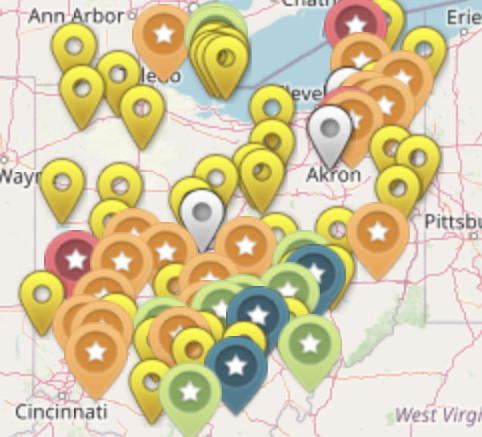
Map
Here is a show of the colors of the markers, to know how to read the map.
| Color | Bortle Scale |
| Black | Level 1 |
| Dark Purple | Level 2 |
| Blue | Level 3 |
| Green | Level 4 |
| Yellow | Level 5 |
| Orange | Level 6 |
| Red | Level 7 |
| White | Level 8 |
To learn more about the Bortle Scale, check out this article. The Ohio State Parks official website can be found here.
Excellent piece! Your analysis is insightful, and the material is well-organized and simple to grasp. Your study and writing of this are greatly appreciated. For those curious about this subject, it’s an excellent resource.
This article was incredibly insightful! Your detailed explanations and well-organized content made it easy to follow along. I appreciate the practical examples you included, as they really helped to illustrate your points. Thank you for sharing such valuable information.
You’ve made this topic very approachable, great job!